Local Government
Mosman Park
Region
Metropolitan
Foreshore - junct of Johnson Pde/Glyde St Mosman Bay
Swan Canoe Club
Mosman Park
Metropolitan
Constructed from 1951
| Type | Status | Date | Documents |
|---|---|---|---|
| (no listings) |
| Type | Status | Date | Documents |
|---|---|---|---|
| (no listings) |
| Type | Status | Date | Grading/Management | |
|---|---|---|---|---|
| Category | ||||
| Municipal Inventory | Adopted | 24 Mar 1998 | Category 5 | |
18987 Swan and Canning Rivers
Individual Building or Group
| Epoch | General | Specific |
|---|---|---|
| Present Use | SOCIAL\RECREATIONAL | Other Sports Building |
| Original Use | SOCIAL\RECREATIONAL | Other Sports Building |
| Type | General | Specific |
|---|---|---|
| Roof | OTHER | Other Material |
| Wall | TIMBER | Weatherboard |
| General | Specific |
|---|---|
| SOCIAL & CIVIC ACTIVITIES | Sport, recreation & entertainment |
This information is provided voluntarily as a public service. The information provided is made available in good faith and is derived from sources believed to be reliable and accurate. However, the information is provided solely on the basis that readers will be responsible for making their own assessment of the matters discussed herein and are advised to verify all relevant representations, statements and information.
Constructed from 1951
This riverside clubhouse has survived almost fifty years of recreational and social use, as well as changes of lease. It is an important part of the foreshore landscape.
Low weatherboard building painted white. Double, gabled roof, tiled with the letters "SCC" in blue tiles. Small barred windows. Set on a grassy area at the foot of the hill of Memorial Park, adjacent to the Swan River. Mead's restaurant is to the north, a small jetty is to the north-west. A small, sandy beach is to the south.
Roof probably originally iron.
Fair
| Ref ID No | Ref Name | Ref Source | Ref Date |
|---|---|---|---|
| George Williams | Nomination | ||
| Tuettemann, E | Between River and Sea. P. 130 | 1991 |
| Ref Number | Description |
|---|---|
| 302 | Municipal Inventory |
| Reserve | Lot/Location | Plan/Diagram | Vol/Folio |
|---|---|---|---|
| A1634/660 |
| Owner | Category |
|---|---|
| Town of Mosman Park | Local Gov't |
This information is provided voluntarily as a public service. The information provided is made available in good faith and is derived from sources believed to be reliable and accurate. However, the information is provided solely on the basis that readers will be responsible for making their own assessment of the matters discussed herein and are advised to verify all relevant representations, statements and information.
3 Baring St Mosman Park
Mosman Park
Metropolitan
Constructed from 1954
| Type | Status | Date | Documents |
|---|---|---|---|
| (no listings) |
| Type | Status | Date | Documents |
|---|---|---|---|
| RHP - Does not warrant assessment | Current | 30 May 2014 |
| Type | Status | Date | Grading/Management | |
|---|---|---|---|---|
| Category | ||||
| (no listings) | ||||
16/4/14 This property is currently residential public housing but due to become vacant on 5th May 2014.
Individual Building or Group
| Epoch | General | Specific |
|---|---|---|
| Present Use | RESIDENTIAL | Single storey residence |
| Original Use | RESIDENTIAL | Single storey residence |
| Type | General | Specific |
|---|---|---|
| Wall | BRICK | Common Brick |
This information is provided voluntarily as a public service. The information provided is made available in good faith and is derived from sources believed to be reliable and accurate. However, the information is provided solely on the basis that readers will be responsible for making their own assessment of the matters discussed herein and are advised to verify all relevant representations, statements and information.
bounded Bateman & Caporn Sts & Swan River Mosman Park
Mosman Park
Metropolitan
| Type | Status | Date | Documents |
|---|---|---|---|
| Heritage List | Adopted | 02 Sep 2014 |
| Type | Status | Date | Documents |
|---|---|---|---|
| (no listings) |
| Type | Status | Date | Grading/Management | |
|---|---|---|---|---|
| Category | ||||
| Municipal Inventory | Adopted | 24 Mar 1998 | Category 2 | |
Landscape
| Epoch | General | Specific |
|---|---|---|
| Present Use | PARK\RESERVE | Park\Reserve |
| Original Use | PARK\RESERVE | Park\Reserve |
| General | Specific |
|---|---|
| SOCIAL & CIVIC ACTIVITIES | Sport, recreation & entertainment |
This information is provided voluntarily as a public service. The information provided is made available in good faith and is derived from sources believed to be reliable and accurate. However, the information is provided solely on the basis that readers will be responsible for making their own assessment of the matters discussed herein and are advised to verify all relevant representations, statements and information.
this reserve marks the eastern point of Mosman Park. It is a pleasant recreational space and offers close views of river activities. Much of the vegetation is relatively undisturbed and contains rare species.
A steeply sloping site much of which is covered with trees and scrub. The top part of the reserve is more level and has trees and grass. The reserve is bisected by Chidley Way which provides access to car parks and to residences near the northern corner of the reserve. At either end of the foreshore boundaries are limestone cliffs. The central foreshore area around Chidley Point has a wide sandy beach from which the "black wall" of the Point Walter Reserve is seen. Vegetation includes wattle, blackboys and pine. Parking facilities dominate this estate.
| Ref ID No | Ref Name | Ref Source | Ref Date |
|---|---|---|---|
| Town of Mosman Park Schedule |
| Ref Number | Description |
|---|---|
| 903 | Municipal Inventory |
| Reserve | Lot/Location | Plan/Diagram | Vol/Folio |
|---|---|---|---|
| A3346 | Lot 81 |
This information is provided voluntarily as a public service. The information provided is made available in good faith and is derived from sources believed to be reliable and accurate. However, the information is provided solely on the basis that readers will be responsible for making their own assessment of the matters discussed herein and are advised to verify all relevant representations, statements and information.
Lot 3 Bateman St Mosman Park
Swan River foreshore NW of Chidley Pt Res
Mosman Park
Metropolitan
| Type | Status | Date | Documents |
|---|---|---|---|
| Heritage List | Adopted | 02 Sep 2014 |
| Type | Status | Date | Documents |
|---|---|---|---|
| (no listings) |
| Type | Status | Date | Grading/Management | |
|---|---|---|---|---|
| Category | ||||
| Municipal Inventory | Adopted | 24 Mar 1998 | Category 2 | |
Landscape
| Epoch | General | Specific |
|---|---|---|
| Present Use | PARK\RESERVE | Park\Reserve |
| Original Use | PARK\RESERVE | Park\Reserve |
| General | Specific |
|---|---|
| DEMOGRAPHIC SETTLEMENT & MOBILITY | Settlements |
This information is provided voluntarily as a public service. The information provided is made available in good faith and is derived from sources believed to be reliable and accurate. However, the information is provided solely on the basis that readers will be responsible for making their own assessment of the matters discussed herein and are advised to verify all relevant representations, statements and information.
Constructed from 1894, Constructed from 1987
A pleasant and well maintained riverside reserve. Named after the home which once stood on the hill behind and was one of the earliest and grandest homes in the district, and the grounds of which included this reserve.
Small, well kept, riverside reserve with terraced lawns and trees. Tiny beach and small public jetty. Retaining walls and steps built of limestone, concrete blocks and bricks, and show evidence of decades of building and repairs. Mature trees include palm and two peppermints. Reserve adjoins, without obvious barriers, the gardens of the overlooking residences.
Very Good
| Ref ID No | Ref Name | Ref Source | Ref Date |
|---|---|---|---|
| Tuettemann, E | Between River and Sea. P. 24, 179 | 1991 |
| Ref Number | Description |
|---|---|
| 904 | Municipal Inventory |
| Reserve | Lot/Location | Plan/Diagram | Vol/Folio |
|---|---|---|---|
| Part Lot 3 |
This information is provided voluntarily as a public service. The information provided is made available in good faith and is derived from sources believed to be reliable and accurate. However, the information is provided solely on the basis that readers will be responsible for making their own assessment of the matters discussed herein and are advised to verify all relevant representations, statements and information.
Bay View Tce Mosman Park
St Hilda's Anglican School for Girls
St Hilda's Church of England School for Girls
Mosman Park
Metropolitan
Constructed from 1930
| Type | Status | Date | Documents |
|---|---|---|---|
| Heritage List | Adopted | 02 Sep 2014 |
| Type | Status | Date | Documents |
|---|---|---|---|
| (no listings) |
| Type | Status | Date | Grading/Management | |
|---|---|---|---|---|
| Category | ||||
| Municipal Inventory | Adopted | 24 Mar 1998 | Category 3 | |
Individual Building or Group
| Epoch | General | Specific |
|---|---|---|
| Original Use | EDUCATIONAL | Secondary School |
| Present Use | EDUCATIONAL | Office or Administration Bldg |
| Type | General | Specific |
|---|---|---|
| Wall | RENDER | Roughcast |
| Roof | TILE | Other Tile |
| General | Specific |
|---|---|
| SOCIAL & CIVIC ACTIVITIES | Education & science |
This information is provided voluntarily as a public service. The information provided is made available in good faith and is derived from sources believed to be reliable and accurate. However, the information is provided solely on the basis that readers will be responsible for making their own assessment of the matters discussed herein and are advised to verify all relevant representations, statements and information.
Constructed from 1930
This is an attractive, substantial and well maintained school building. Generations of girls have attended school here and many have lived here. The building appears to have remained structurally intact although uses of rooms have changed. It contributes a formality to the streetscape.
A two storey masonry building with external walls rough rendered and vine covered. Hipped roof with orange tiles. Limestone foundations. Metal framed windows, some older, some recent aluminium replacements. Pillars either side of entrance porch. Double entrance doors. Building has a large, central hall with smaller rooms around, boarding house upstairs. Hall has red brick internal walls and timber floor, stage at one end. Other rooms carpeted and brickwork painted. Part of school campus of sympathetic, but physically different, buildings. Set in well kept, landscaped gardens of lawns, mature trees and flower beds.
Some windows replaced. Internal renovations.
Very Good
| Ref ID No | Ref Name | Ref Source | Ref Date |
|---|---|---|---|
| Tuettemann, E | Between River and Sea. P. 159-60 | 1991 |
| Ref Number | Description |
|---|---|
| 104 | Municipal Inventory |
| Reserve | Lot/Location | Plan/Diagram | Vol/Folio |
|---|---|---|---|
| Lot 27 |
This information is provided voluntarily as a public service. The information provided is made available in good faith and is derived from sources believed to be reliable and accurate. However, the information is provided solely on the basis that readers will be responsible for making their own assessment of the matters discussed herein and are advised to verify all relevant representations, statements and information.
Bay View Tce Mosman Park
Mosman Park
Metropolitan
Constructed from 1993
| Type | Status | Date | Documents |
|---|---|---|---|
| (no listings) |
| Type | Status | Date | Documents |
|---|---|---|---|
| (no listings) |
| Type | Status | Date | Grading/Management | |
|---|---|---|---|---|
| Category | ||||
| Municipal Inventory | Adopted | 24 Mar 1998 | Category 2 | |
Individual Building or Group
| Epoch | General | Specific |
|---|---|---|
| Original Use | RELIGIOUS | Church, Cathedral or Chapel |
| Present Use | RELIGIOUS | Church, Cathedral or Chapel |
| Type | General | Specific |
|---|---|---|
| Roof | TILE | Other Tile |
| Wall | STONE | Limestone |
| General | Specific |
|---|---|
| SOCIAL & CIVIC ACTIVITIES | Religion |
This information is provided voluntarily as a public service. The information provided is made available in good faith and is derived from sources believed to be reliable and accurate. However, the information is provided solely on the basis that readers will be responsible for making their own assessment of the matters discussed herein and are advised to verify all relevant representations, statements and information.
Constructed from 1993
A beautiful chapel designed by a Fremantle based architect. Important as the place of worship in a church school.
Ashlar limestone walls. Bell tower on north west corner with St Hilda's crest in carved stone on the wall. Main roof gabled, orange tiles. Most windows lancet with metal framed glass. Some clear glass, some patterned glass, some coloured patterned glass, some stained glass work. Circular stained glass window to the west. Arches at lowest level of tower. Heavy jarrah doors, main double doors at north west entrance have heavy iron handles. Interior has smooth limestone walls with arcades either side. Tiled floor. Extensive use of jarrah for roof beams and lining, pews and other furniture, stairs and gallery railing. Organ in gallery dates from 1875. Hanging light fittings in iron and glass to complement style of windows. Foundation stone near entrance, date 2 September 1990. Vines growing over south wall. Set in wall kept, landscaped garden of lawns, paths and trimmed hedges. Two mature Norfolk Island Pines to the south.
Very Good
| Name | Type | Year From | Year To |
|---|---|---|---|
| Brian Klopper | Architect | - | - |
| Ref ID No | Ref Name | Ref Source | Ref Date |
|---|---|---|---|
| Town of Mosman Park files |
| Ref Number | Description |
|---|---|
| 105 | Municipal Inventory |
This information is provided voluntarily as a public service. The information provided is made available in good faith and is derived from sources believed to be reliable and accurate. However, the information is provided solely on the basis that readers will be responsible for making their own assessment of the matters discussed herein and are advised to verify all relevant representations, statements and information.
Bay View Tce Mosman Park
Mosman Park
Metropolitan
Constructed from 1926
| Type | Status | Date | Documents |
|---|---|---|---|
| (no listings) |
| Type | Status | Date | Documents |
|---|---|---|---|
| (no listings) |
| Type | Status | Date | Grading/Management | |
|---|---|---|---|---|
| Category | ||||
| Municipal Inventory | Adopted | 24 Mar 1998 | Category 5 | |
Individual Building or Group
| Epoch | General | Specific |
|---|---|---|
| Original Use | SOCIAL\RECREATIONAL | Other Sports Building |
| Present Use | SOCIAL\RECREATIONAL | Other Sports Building |
| Type | General | Specific |
|---|---|---|
| Roof | METAL | Other Metal |
| Wall | BRICK | Other Brick |
| General | Specific |
|---|---|
| SOCIAL & CIVIC ACTIVITIES | Sport, recreation & entertainment |
This information is provided voluntarily as a public service. The information provided is made available in good faith and is derived from sources believed to be reliable and accurate. However, the information is provided solely on the basis that readers will be responsible for making their own assessment of the matters discussed herein and are advised to verify all relevant representations, statements and information.
Constructed from 1926, Constructed from 1957
A fairly ordinary club building with an extraordinary view. An important recreational and social centre for generations of local residents.
Yellow brick building with a low metal roof and large, aluminium framed windows. Large, open, social room. Facility rooms on south and west. Mostly carpeted but has timber dance floor. Timber paneled bar. Well maintained greens and gardens. Car park on south-west of site. Panorama to the east includes views of Point Walter, Melville Water, the Perth City skyline and Mosman Bay.
Major renovations 1969. Other minor alterations. Gradual development of greens.
Very good
| Name | Type | Year From | Year To |
|---|---|---|---|
| Peter Grigg | Architect | 1957 | 1965 |
| LW Buckeridge & Assoc. | Architect | 1969 | - |
| Ref ID No | Ref Name | Ref Source | Ref Date |
|---|---|---|---|
| Town of Mosman Park files | |||
| Tuettemann, E | Between River and Sea. P. 121, 130-31 | 1991 |
| Ref Number | Description |
|---|---|
| 301 | Municipal Inventory |
| Reserve | Lot/Location | Plan/Diagram | Vol/Folio |
|---|---|---|---|
| A1666 |
This information is provided voluntarily as a public service. The information provided is made available in good faith and is derived from sources believed to be reliable and accurate. However, the information is provided solely on the basis that readers will be responsible for making their own assessment of the matters discussed herein and are advised to verify all relevant representations, statements and information.
5 Bay View Tce Mosman Park
MacKellar-Hall House
Mosman Park
Metropolitan
Constructed from 1932
| Type | Status | Date | Documents |
|---|---|---|---|
| Heritage List | Adopted | 02 Sep 2014 |
| Type | Status | Date | Documents |
|---|---|---|---|
| RHP - Does not warrant assessment | Current | 26 Jul 2013 |
| Type | Status | Date | Grading/Management | |
|---|---|---|---|---|
| Category | ||||
| Municipal Inventory | Adopted | 24 Mar 1998 | Category 5 | |
A two storey brick and tile residence in the inter-war Old English style with half timbered gables, steeply pitched roofs and tall decorative brick chimneys.
Individual Building or Group
| Epoch | General | Specific |
|---|---|---|
| Original Use | RESIDENTIAL | Two storey residence |
| Present Use | RESIDENTIAL | Two storey residence |
| Style |
|---|
| Inter-War Old English |
| Type | General | Specific |
|---|---|---|
| Roof | TILE | Terracotta Tile |
| Wall | BRICK | Face Brick |
| General | Specific |
|---|---|
| DEMOGRAPHIC SETTLEMENT & MOBILITY | Settlements |
This information is provided voluntarily as a public service. The information provided is made available in good faith and is derived from sources believed to be reliable and accurate. However, the information is provided solely on the basis that readers will be responsible for making their own assessment of the matters discussed herein and are advised to verify all relevant representations, statements and information.
Constructed from 1932
A large house by a well regarded WA architect for a client of considerable community standing. Appears to have been altered very little. An example of a home designed to take advantage of views of the Swan River.
A two storey house with garage under, painted brickwork and orange tiled roof. Archway to front door. Wooden shutters to windows. Two large balconies at rear, river side, and a tiny balcony to the front, wrought iron detailing to balconies. Corner block has large garden with mature trees and shrubs. Extensive river views. Diagonally opposite St Hilda's School. Streetscape of large homes taking advantage of views.
Minimal renovations and maintenance.
Fair
| Name | Type | Year From | Year To |
|---|---|---|---|
| Reginald Summerhayes | Architect | - | - |
| Ref ID No | Ref Name | Ref Source | Ref Date |
|---|---|---|---|
| Beiers, George | Homes of Australia. P.91 | ||
| Brans family (current owners) | Have original plans & specifications | ||
| Cuffley, Peter | Australian Houses of the '20s & '30s. P. 80-81 | 1989 |
| Ref Number | Description |
|---|---|
| 501 | Municipal Inventory |
| Reserve | Lot/Location | Plan/Diagram | Vol/Folio |
|---|---|---|---|
| Lot 58 |
This information is provided voluntarily as a public service. The information provided is made available in good faith and is derived from sources believed to be reliable and accurate. However, the information is provided solely on the basis that readers will be responsible for making their own assessment of the matters discussed herein and are advised to verify all relevant representations, statements and information.
between Bay View Tce & Swan River Mosman Park
Mosman Park
Metropolitan
| Type | Status | Date | Documents |
|---|---|---|---|
| Heritage List | Adopted | 02 Sep 2014 |
| Type | Status | Date | Documents |
|---|---|---|---|
| (no listings) |
| Type | Status | Date | Grading/Management | |
|---|---|---|---|---|
| Category | ||||
| Register of the National Estate | UNKNOWN | |||
| Municipal Inventory | Adopted | 24 Mar 1998 | Category 2 | |
Landscape
| Epoch | General | Specific |
|---|---|---|
| Original Use | PARK\RESERVE | Park\Reserve |
| Present Use | PARK\RESERVE | Park\Reserve |
| General | Specific |
|---|---|
| SOCIAL & CIVIC ACTIVITIES | Sport, recreation & entertainment |
This information is provided voluntarily as a public service. The information provided is made available in good faith and is derived from sources believed to be reliable and accurate. However, the information is provided solely on the basis that readers will be responsible for making their own assessment of the matters discussed herein and are advised to verify all relevant representations, statements and information.
This reserve has one of the best panoramic views of the Swan River. This place has significance due to the practice of scattering ashes from the lookout.
Reserve along foreshore with level, lawned area at the top and steep cliffs with native scrub sloping to very narrow beach and rocks at the river edge. Top area has trees, a carpark and a lookout place, a wide lawn area with a walking and cycling path. The wall at the lookout has some plaques in memory of those whose ashes have been scattered from the place.
| Ref ID No | Ref Name | Ref Source | Ref Date |
|---|---|---|---|
| Tuettemann, E | Between River and Sea. P. 174-175 | 1991 |
| Ref Number | Description |
|---|---|
| 906 | Municipal Inventory |
| Reserve | Lot/Location | Plan/Diagram | Vol/Folio |
|---|---|---|---|
| 8369 |
This information is provided voluntarily as a public service. The information provided is made available in good faith and is derived from sources believed to be reliable and accurate. However, the information is provided solely on the basis that readers will be responsible for making their own assessment of the matters discussed herein and are advised to verify all relevant representations, statements and information.
Blackwell Reach Between Roe & Chidley Pnts Mosman Park
Below CSR Refinery on Waterfront
Mosman Park
Metropolitan
Constructed from 1927 to 1997
| Type | Status | Date | Documents |
|---|---|---|---|
| Heritage List | Adopted | 02 Sep 2014 |
| Type | Status | Date | Documents |
|---|---|---|---|
| (no listings) |
| Type | Status | Date | Grading/Management | |
|---|---|---|---|---|
| Category | ||||
| (no listings) | ||||
Individual Building or Group
| Epoch | General | Specific |
|---|---|---|
| Present Use | VACANT\UNUSED | Vacant\Unused |
| Original Use | GOVERNMENTAL | Pumping Station |
| Type | General | Specific |
|---|---|---|
| Wall | BRICK | Common Brick |
This information is provided voluntarily as a public service. The information provided is made available in good faith and is derived from sources believed to be reliable and accurate. However, the information is provided solely on the basis that readers will be responsible for making their own assessment of the matters discussed herein and are advised to verify all relevant representations, statements and information.
This information is provided voluntarily as a public service. The information provided is made available in good faith and is derived from sources believed to be reliable and accurate. However, the information is provided solely on the basis that readers will be responsible for making their own assessment of the matters discussed herein and are advised to verify all relevant representations, statements and information.
Lot 436 Boundary Rd Mosman Park
Reserve 39124
The Monument
Mosman Park
Metropolitan
Constructed from 1878 to 1880
| Type | Status | Date | Documents |
|---|---|---|---|
| Heritage List | Adopted | 02 Sep 2014 |
| Type | Status | Date | Documents |
|---|---|---|---|
| (no listings) |
| Type | Status | Date | Grading/Management | |
|---|---|---|---|---|
| Category | ||||
| Municipal Inventory | Adopted | 24 Mar 1998 | Category 2 | |
Historic site
| Epoch | General | Specific |
|---|---|---|
| Original Use | OTHER | Other |
| Present Use | OTHER | Other |
| Type | General | Specific |
|---|---|---|
| Wall | STONE | Limestone |
| General | Specific |
|---|---|
| OUTSIDE INFLUENCES | Water, power, major t'port routes |
This information is provided voluntarily as a public service. The information provided is made available in good faith and is derived from sources believed to be reliable and accurate. However, the information is provided solely on the basis that readers will be responsible for making their own assessment of the matters discussed herein and are advised to verify all relevant representations, statements and information.
Constructed from 1880, Constructed from 1878
The obelisk is considered to be the most important structure in Mosman Park and is the major emblem on the Coat of Arms of the Town of Mosman Park.
The obelisk is a tiered limestone structure situated at the highest point of the hill. It is surrounded by limestone retaining walls and native scrub. Close by to the east is the roof of the reservoir. To the north and west the hill falls away sharply. The obelisk can be seen from nay parts of Mosman Park and from further afield.
The reservoir was enlarged and built around the obelisk in 1934-35. The obelisk was moved in 1983, 48 metres south west, so as not to be in the reservoir, and restored at the same time.
Fair
| Ref ID No | Ref Name | Ref Source | Ref Date |
|---|---|---|---|
| Tuettemann, E | Between River and Sea. P.196-7 | 1991 | |
| National Trust Files |
| Ref Number | Description |
|---|---|
| 005 | Municipal Inventory number |
| Reserve | Lot/Location | Plan/Diagram | Vol/Folio |
|---|---|---|---|
| 13374 |
This information is provided voluntarily as a public service. The information provided is made available in good faith and is derived from sources believed to be reliable and accurate. However, the information is provided solely on the basis that readers will be responsible for making their own assessment of the matters discussed herein and are advised to verify all relevant representations, statements and information.
20 Bryant Av Mosman Park
Mosman Park
Metropolitan
Constructed from 1947
| Type | Status | Date | Documents |
|---|---|---|---|
| (no listings) |
| Type | Status | Date | Documents |
|---|---|---|---|
| RHP - Does not warrant assessment | Current | 14 Dec 2012 |
| Type | Status | Date | Grading/Management | |
|---|---|---|---|---|
| Category | ||||
| (no listings) | ||||
Individual Building or Group
| Epoch | General | Specific |
|---|---|---|
| Present Use | VACANT\UNUSED | Vacant\Unused |
| Original Use | RESIDENTIAL | Single storey residence |
| Type | General | Specific |
|---|---|---|
| Wall | BRICK | Common Brick |
This information is provided voluntarily as a public service. The information provided is made available in good faith and is derived from sources believed to be reliable and accurate. However, the information is provided solely on the basis that readers will be responsible for making their own assessment of the matters discussed herein and are advised to verify all relevant representations, statements and information.
Lot 12059 Chine Pl & The Coombe Mosman Park
Swan River foreshore, 8.6 km from Narrows Bridge
Mosman Park
Metropolitan
| Type | Status | Date | Documents |
|---|---|---|---|
| Heritage List | Adopted | 02 Sep 2014 |
| Type | Status | Date | Documents |
|---|---|---|---|
| (no listings) |
| Type | Status | Date | Grading/Management | |
|---|---|---|---|---|
| Category | ||||
| Municipal Inventory | Adopted | 24 Mar 1998 | ||
| Library Id | Title | Medium | Year Of Publication |
|---|---|---|---|
| 2409 | Swan River estuary Pleistocene and Holocene sites : nomination of a geological monument for the Register of the National Estate. | Book | 1992 |
Landscape
| Epoch | General | Specific |
|---|---|---|
| Present Use | PARK\RESERVE | Park\Reserve |
| Original Use | PARK\RESERVE | Park\Reserve |
| General | Specific |
|---|---|
| SOCIAL & CIVIC ACTIVITIES | Sport, recreation & entertainment |
This information is provided voluntarily as a public service. The information provided is made available in good faith and is derived from sources believed to be reliable and accurate. However, the information is provided solely on the basis that readers will be responsible for making their own assessment of the matters discussed herein and are advised to verify all relevant representations, statements and information.
As the site of some of the earliest European settlement in the area, this foreshore is significant. However the area has been extensively altered and subdivision has reduced open space to a tiny fraction of the original locations. The reserve has social significance as the remnant of the site about which early history revolves.
The Coombe reserve is a small park at the foreshore. It has lawns, a narrow beach, a playground, limestone cliffs and a mixture of native and introduced vegetation. Native river rushes at the water's edge. Some small caves. Private building in cliff face, high walls and gates.
| Ref ID No | Ref Name | Ref Source | Ref Date |
|---|---|---|---|
| Tuettemann, E | Between River and Sea. P. 185-190 | 1991 |
| Ref Number | Description |
|---|---|
| 905 | Municipal Inventory |
| Reserve | Lot/Location | Plan/Diagram | Vol/Folio |
|---|---|---|---|
| 25221/9800 |
This information is provided voluntarily as a public service. The information provided is made available in good faith and is derived from sources believed to be reliable and accurate. However, the information is provided solely on the basis that readers will be responsible for making their own assessment of the matters discussed herein and are advised to verify all relevant representations, statements and information.
36 Fairlight St Mosman Park
Mosman Park
Metropolitan
Constructed from 1927
| Type | Status | Date | Documents |
|---|---|---|---|
| Heritage List | Adopted | 02 Sep 2014 |
| Type | Status | Date | Documents |
|---|---|---|---|
| (no listings) |
| Type | Status | Date | Grading/Management | |
|---|---|---|---|---|
| Category | ||||
| Municipal Inventory | Adopted | 24 Mar 1998 | Category 2 | |
Individual Building or Group
| Epoch | General | Specific |
|---|---|---|
| Original Use | RELIGIOUS | Church, Cathedral or Chapel |
| Present Use | RELIGIOUS | Church, Cathedral or Chapel |
| Type | General | Specific |
|---|---|---|
| Wall | BRICK | Rendered Brick |
| Roof | TILE | Other Tile |
| General | Specific |
|---|---|
| SOCIAL & CIVIC ACTIVITIES | Religion |
This information is provided voluntarily as a public service. The information provided is made available in good faith and is derived from sources believed to be reliable and accurate. However, the information is provided solely on the basis that readers will be responsible for making their own assessment of the matters discussed herein and are advised to verify all relevant representations, statements and information.
Constructed from 1927
This building is an important part of the spiritual and social life of the community. It is a place of regular meeting and one in which the major events of life are celebrated. It is an attractive example of a small suburban church of its era, and one which appears to have remained fairly intact.
Red brick church with rendered banding and mouldings around Gothic windows. Six buttresses either side and others to corners. Orange tiled roof. Major brick and tile extensions to rear. Above extensions the rear wall of the original church is weatherboard. The church is on a small block and occupies almost all of the land. The front and east side of the building are on, or close to, the property boundary.
1957 brick and tile extensions to rear
Good
| Ref ID No | Ref Name | Ref Source | Ref Date |
|---|---|---|---|
| Tuettemann, E | Between River and Sea. P. 169-171 | 1991 |
| Ref Number | Description |
|---|---|
| 206 | Municipal Inventory |
| Owner | Category |
|---|---|
| Baptist Churches of WA | Church Property |
This information is provided voluntarily as a public service. The information provided is made available in good faith and is derived from sources believed to be reliable and accurate. However, the information is provided solely on the basis that readers will be responsible for making their own assessment of the matters discussed herein and are advised to verify all relevant representations, statements and information.
51 Fairlight St Mosman Park
Mosman Park
Metropolitan
| Type | Status | Date | Documents |
|---|---|---|---|
| Heritage List | Adopted | 02 Sep 2014 |
| Type | Status | Date | Documents |
|---|---|---|---|
| (no listings) |
| Type | Status | Date | Grading/Management | |
|---|---|---|---|---|
| Category | ||||
| Municipal Inventory | Adopted | 24 Mar 1998 | Category 2 | |
Landscape
| Epoch | General | Specific |
|---|---|---|
| Original Use | PARK\RESERVE | Park\Reserve |
| Present Use | PARK\RESERVE | Park\Reserve |
| General | Specific |
|---|---|
| PEOPLE | Early settlers |
This information is provided voluntarily as a public service. The information provided is made available in good faith and is derived from sources believed to be reliable and accurate. However, the information is provided solely on the basis that readers will be responsible for making their own assessment of the matters discussed herein and are advised to verify all relevant representations, statements and information.
This is a small patch of publicly accessible garden in an area of medium density housing. It is well maintained and pleasant. This is a tangible reminder of people and an event that might otherwise be lost to the community. While the tragedy occurred in another place, the three youths were locals and Geoffrey Dalziel lived in the house on this block. The park honours the bravery of the three youths and is a memorial to Geoffrey Dalziel.
Small park on what was probably originally a house block. The park has lawn, native trees and a hedge of large shrubs along the western fence. There is a drinking fountain and pine barrier posts. A limestone rock carries a plaque identifying the tree boys and the tragedy that is remembered. The park is in an area of small house blocks with a variety of housing types.
| Ref ID No | Ref Name | Ref Source | Ref Date |
|---|---|---|---|
| Information given to Lindy Brophy by Kerry Davies | |||
| Tuettemann, E | Between River and Sea. P. 191-2 | 1991 |
| Ref Number | Description |
|---|---|
| 911 | Municipal Inventory |
| Reserve | Lot/Location | Plan/Diagram | Vol/Folio |
|---|---|---|---|
| Part Lot 117 |
This information is provided voluntarily as a public service. The information provided is made available in good faith and is derived from sources believed to be reliable and accurate. However, the information is provided solely on the basis that readers will be responsible for making their own assessment of the matters discussed herein and are advised to verify all relevant representations, statements and information.
13 Glanville St Mosman Park
Mosman Park
Metropolitan
Constructed from 1913
| Type | Status | Date | Documents |
|---|---|---|---|
| (no listings) |
| Type | Status | Date | Documents |
|---|---|---|---|
| (no listings) |
| Type | Status | Date | Grading/Management | |
|---|---|---|---|---|
| Category | ||||
| Municipal Inventory | Adopted | 24 Mar 1998 | Category 5 | |
Individual Building or Group
| Epoch | General | Specific |
|---|---|---|
| Original Use | RESIDENTIAL | Single storey residence |
| Present Use | RESIDENTIAL | Single storey residence |
| Type | General | Specific |
|---|---|---|
| Roof | METAL | Corrugated Iron |
| Wall | STONE | Limestone |
| General | Specific |
|---|---|
| DEMOGRAPHIC SETTLEMENT & MOBILITY | Settlements |
This information is provided voluntarily as a public service. The information provided is made available in good faith and is derived from sources believed to be reliable and accurate. However, the information is provided solely on the basis that readers will be responsible for making their own assessment of the matters discussed herein and are advised to verify all relevant representations, statements and information.
Constructed from 1913
Attractive older home which retains an original appearance.
Rough limestone with red brick quoins. Hipped, corrugated metal roof. Two chimneys. Bullnosed verandah extends around side of house to cover carport. Intricately turned verandah posts. Concrete verandah floor. Sash windows. Stained glass front door panel, fan and side lights. Two storey, brick addition to rear. Brick paved driveway and paths. Low picket fence at street. Two mature pine trees in small front garden, either side of central front entrance.
1989 two storey extension to rear. 1995 carport. Internal renovations.
Very Good
| Ref ID No | Ref Name | Ref Source | Ref Date |
|---|---|---|---|
| Town of Mosman Park files | |||
| West Australian | Classified liftout P. 8 | 09/01/1993 |
| Ref Number | Description |
|---|---|
| 502 | Municipal Inventory |
| Reserve | Lot/Location | Plan/Diagram | Vol/Folio |
|---|---|---|---|
| Lot 24 |
This information is provided voluntarily as a public service. The information provided is made available in good faith and is derived from sources believed to be reliable and accurate. However, the information is provided solely on the basis that readers will be responsible for making their own assessment of the matters discussed herein and are advised to verify all relevant representations, statements and information.
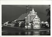
13 Glyde St Mosman Park
Harmony Antiques
The Salvation Army Citadel
Mosman Park
Metropolitan
Constructed from 1920
| Type | Status | Date | Documents |
|---|---|---|---|
| Heritage List | Adopted | 02 Sep 2014 |
| Type | Status | Date | Documents |
|---|---|---|---|
| (no listings) |
| Type | Status | Date | Grading/Management | |
|---|---|---|---|---|
| Category | ||||
| Municipal Inventory | Adopted | 24 Mar 1998 | Category 2 | |
Individual Building or Group
| Epoch | General | Specific |
|---|---|---|
| Present Use | COMMERCIAL | Shop\Retail Store {single} |
| Original Use | RELIGIOUS | Church Hall |
| Type | General | Specific |
|---|---|---|
| Wall | BRICK | Painted Brick |
| Roof | OTHER | Other Material |
| General | Specific |
|---|---|
| SOCIAL & CIVIC ACTIVITIES | Religion |
This information is provided voluntarily as a public service. The information provided is made available in good faith and is derived from sources believed to be reliable and accurate. However, the information is provided solely on the basis that readers will be responsible for making their own assessment of the matters discussed herein and are advised to verify all relevant representations, statements and information.
Constructed from 1920
The Citadel is an attractive small church building which is quite intact. Its use as an antique shop has enabled its preservation and continued public accessibility. It has importance as a meeting place over five decades, and as an antique sop over two and a half decades. This building is an important part of the Glyde Street, commercial to residential streetscape.
Gable fronted building with decorative moulding and arched windows and doorway. Date "1920" and words "THE (two words deleted) CITADEL" in moulding on facade. Painted brickwork at front, red brick east side, rendered west side, buttresses at sides. Small weatherboard extension at rear, probably original, in poor condition. Timber floor. Timber ceiling with tie rods and circular, latticed ventilation. Intricately carved woodwork at bases of ceiling beams. Corrugated metal roof. Clear glass in front windows, opaque glass in side windows. Original brick toilet still at rear of block. New shed at rear. Peppermint trees on the verge. The Citadel is complemented by the old weatherboard shop to the east, which is similar in scale and style. To the west Glyde Street is predominantly a small shop area, to the east Glyde Street becomes residential.
Used as shop since 1971. Front doors and windows do not appear to be original
Good
| Name | Type | Year From | Year To |
|---|---|---|---|
| Colonel Percival Dale | Architect | - | - |
| Ref ID No | Ref Name | Ref Source | Ref Date |
|---|---|---|---|
| National Trust Assessment | |||
| Tuettemann, E | Between River and Sea. P. 106 | 1991 |
| Ref Number | Description |
|---|---|
| 409 | Municipal Inventory |
| Reserve | Lot/Location | Plan/Diagram | Vol/Folio |
|---|---|---|---|
| Lot 17 |
This information is provided voluntarily as a public service. The information provided is made available in good faith and is derived from sources believed to be reliable and accurate. However, the information is provided solely on the basis that readers will be responsible for making their own assessment of the matters discussed herein and are advised to verify all relevant representations, statements and information.
1-5 Glyde St Mosman Park
Glyde Gallery 5
Video shop 1, florist 1A, Casablanca Rest 3
Mosman Park
Metropolitan
Constructed from 1909
| Type | Status | Date | Documents |
|---|---|---|---|
| Heritage List | Adopted | 02 Sep 2014 |
| Type | Status | Date | Documents |
|---|---|---|---|
| (no listings) |
| Type | Status | Date | Grading/Management | |
|---|---|---|---|---|
| Category | ||||
| Municipal Inventory | Adopted | 24 Mar 1998 | Category 2 | |
Individual Building or Group
| Epoch | General | Specific |
|---|---|---|
| Present Use | COMMERCIAL | Shopping Complex |
| Original Use | COMMERCIAL | Shop\Retail Store {single} |
| Type | General | Specific |
|---|---|---|
| Roof | METAL | Corrugated Iron |
| Wall | RENDER | Other Render |
| General | Specific |
|---|---|
| OCCUPATIONS | Commercial & service industries |
This information is provided voluntarily as a public service. The information provided is made available in good faith and is derived from sources believed to be reliable and accurate. However, the information is provided solely on the basis that readers will be responsible for making their own assessment of the matters discussed herein and are advised to verify all relevant representations, statements and information.
Constructed from 1909
This row of shops and attached house are some of the original commercial development in Mosman Park. They have survived with their basic form fairly intact. A good example of the main street, strip shopping format typical of its era, and one that continues to be commercially viable despite shopping centre development. This is the focal building in a streetscape of small shops.
Row of attached shops (1-3), and house (5). Rendered masonry and green tiles to front facade of shops. High, decorative facade hides corrugated metal roof. Panelled timber doors. Recent metal awning renovation. Some timber floors, some concrete floors. Some corrugated metal ceilings, some plain ceilings. Evidence of many minor changes at the rear. House set back and at a higher level. Limestone foundations, front wall rendered, side wall red brick. Verandah with timber posts and balustrade. Brick steps entrance. Small front garden with picket fence. Timber doors and architraves, some not original. Fan light and side light to front door. Timber floor. Archway entrance hall. Main room has original ceiling with large rose. Brick extension to rear, small rear garden with original toilet. Brick paved footpath with recently planted trees. Shopping area continues around corner on Stirling Highway and across Glyde Street.
Rear extensions to house. 1981 brick toilets at rear of shops.
Good
| Ref ID No | Ref Name | Ref Source | Ref Date |
|---|---|---|---|
| Town of Mosman Park files |
| Ref Number | Description |
|---|---|
| 408 | Municipal Inventory |
| Reserve | Lot/Location | Plan/Diagram | Vol/Folio |
|---|---|---|---|
| Lot 13 |
| Owner | Category |
|---|---|
| PT Swarbrick | Other Private |
| Mica Pty Ltd | Other Private |
This information is provided voluntarily as a public service. The information provided is made available in good faith and is derived from sources believed to be reliable and accurate. However, the information is provided solely on the basis that readers will be responsible for making their own assessment of the matters discussed herein and are advised to verify all relevant representations, statements and information.
46 Glyde St Mosman Park
Mosman Park
Metropolitan
| Type | Status | Date | Documents |
|---|---|---|---|
| (no listings) |
| Type | Status | Date | Documents |
|---|---|---|---|
| (no listings) |
| Type | Status | Date | Grading/Management | |
|---|---|---|---|---|
| Category | ||||
| (no listings) | ||||
Demolition advised by LGA - no date or reason given.
Individual Building or Group
| Epoch | General | Specific |
|---|---|---|
| Present Use | RESIDENTIAL | Single storey residence |
This information is provided voluntarily as a public service. The information provided is made available in good faith and is derived from sources believed to be reliable and accurate. However, the information is provided solely on the basis that readers will be responsible for making their own assessment of the matters discussed herein and are advised to verify all relevant representations, statements and information.
48 Glyde St Mosman Park
Mosman Park
Metropolitan
| Type | Status | Date | Documents |
|---|---|---|---|
| (no listings) |
| Type | Status | Date | Documents |
|---|---|---|---|
| (no listings) |
| Type | Status | Date | Grading/Management | |
|---|---|---|---|---|
| Category | ||||
| Municipal Inventory | Adopted | 24 Mar 1998 | Category 5 | |
Demolition advised by LGA - no date or reason given.
Individual Building or Group
| Epoch | General | Specific |
|---|---|---|
| Present Use | RESIDENTIAL | Other |
| Original Use | RESIDENTIAL | Single storey residence |
| Type | General | Specific |
|---|---|---|
| Wall | BRICK | Common Brick |
| Roof | METAL | Other Metal |
| General | Specific |
|---|---|
| DEMOGRAPHIC SETTLEMENT & MOBILITY | Settlements |
This information is provided voluntarily as a public service. The information provided is made available in good faith and is derived from sources believed to be reliable and accurate. However, the information is provided solely on the basis that readers will be responsible for making their own assessment of the matters discussed herein and are advised to verify all relevant representations, statements and information.
One of the early homes in Mosman Park. A. Armanasco owned some of the shops on Stirling Highway. This was the second local home of the family. Has significance as one of a pair owned and lived in by the same family and with matching front walls.
Tuck pointed red brick with rendered banding. Tile contoured metal, hipped roof. Gable over front, double, sash windows with stucco and timber and decorative timber gable detail. Verandah roof is extension of main roof. Verandah has been enclosed in brick and has metal awnings over windows. Front retaining wall of limestone and cast iron lacework matches that of its neighbour 50 Glyde Street.
Verandah enclosure. 1992 patio/games room.
Fair
| Ref ID No | Ref Name | Ref Source | Ref Date |
|---|---|---|---|
| Tuettemann, E | Between River and Sea. P. 55 | 1991 | |
| Town of Mosman Park files |
| Ref Number | Description |
|---|---|
| 503 | Municipal Inventory |
| Reserve | Lot/Location | Plan/Diagram | Vol/Folio |
|---|---|---|---|
| Lot 1 |
This information is provided voluntarily as a public service. The information provided is made available in good faith and is derived from sources believed to be reliable and accurate. However, the information is provided solely on the basis that readers will be responsible for making their own assessment of the matters discussed herein and are advised to verify all relevant representations, statements and information.